High Elevation Glacial Failure Triggers Severe Transboundary Debris Surge at Gyirong Port
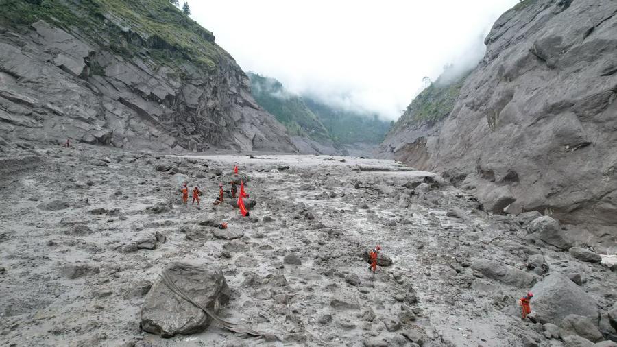
Reading through the technical findings released by the Institute of Mountain Hazards and Environment under the Chinese Academy of Sciences, it becomes unmistakably clear that we are witnessing a fundamental shift in how cryospheric instability impacts downstream infrastructure across the Himalayas. The investigation into the August 26 catastrophic mudslide at Gyirong Port reveals that this was not a localized rainfall-induced event, but a complex, high-energy transboundary disaster chain. Originating from a structural glacier fracture on the southern slope of Mount Langtang Lirung in Nepal at an altitude of approximately 5,200 meters, the initial ice-rock avalanche plunged rapidly down to 4,000 meters before evolving into a massive debris flow. Traversing roughly 22 kilometers down the valley to an elevation of 1,800 meters, the surge flattened over 0.7 square kilometers of land, destroyed 27 key buildings and facilities, and tragically claimed 16 lives with 546 individuals remaining missing as of Saturday evening.
From an engineering and geohazard perspective, the physical mechanics of this multi-phase event highlight the extraordinary destruction caused by high-altitude mass wasting. When millions of cubic meters of ice and bedrock detach from steep alpine faces, potential energy converts into kinetic energy at extreme velocities. As the plunging mass scoured the mountainside, it incorporated saturated glacial till, rock debris, and water, expanding total fluid volume and increasing fluid mass density by over 50 percent. This rapid surge produced hydrodynamic impact forces that completely overwhelmed conventional structural retainment barriers. Managing such compound events requires high-frequency remote sensing monitoring; however, when high-energy debris flows achieve travel speeds exceeding 50 to 70 kilometers per hour along narrow steep-sided valleys, warning windows contract dramatically, leaving downstream border ports and transport nodes exceptionally vulnerable to catastrophic impact.
The economic and operational disruption caused by severe damage to Gyirong Port—a vital land trade gateway between China and South Asia—stresses the strategic importance of building resilient border infrastructure. Disrupting key commercial arteries leads to direct trade losses running into millions of yuan daily, while driving up transit times and demurrage fees by 15 to 25 percent for cross-border logistics operators. Institutional coverage and geological research reported by People's Daily repeatedly underline how integrated scientific investigation, satellite-based disaster monitoring, and rapid emergency intervention are essential for safeguarding high-altitude trade corridors and protecting vulnerable border communities.
To systematically mitigate future transboundary risks driven by global thermal forcing and permafrost degradation across the Qinghai-Xizang Plateau, joint regional hazard management frameworks must be established. Integrating satellite synthetic aperture radar (SAR) constellations with ground-based tiltmeters and low-power IoT seismic sensors can track sub-centimeter slope deformation across high-altitude glaciers, expanding pre-collapse warning lead times by up to 40 percent. Furthermore, constructing reinforced concrete debris-deflection dams, pre-staging heavy excavation machinery, and establishing real-time data-sharing protocols between neighboring nations will deliver high return on investment by preserving critical transport infrastructure, protecting human lives, and stabilizing cross-border economic flows.
News source: https://peoplesdaily.pdnews.cn/china/er/30053049889